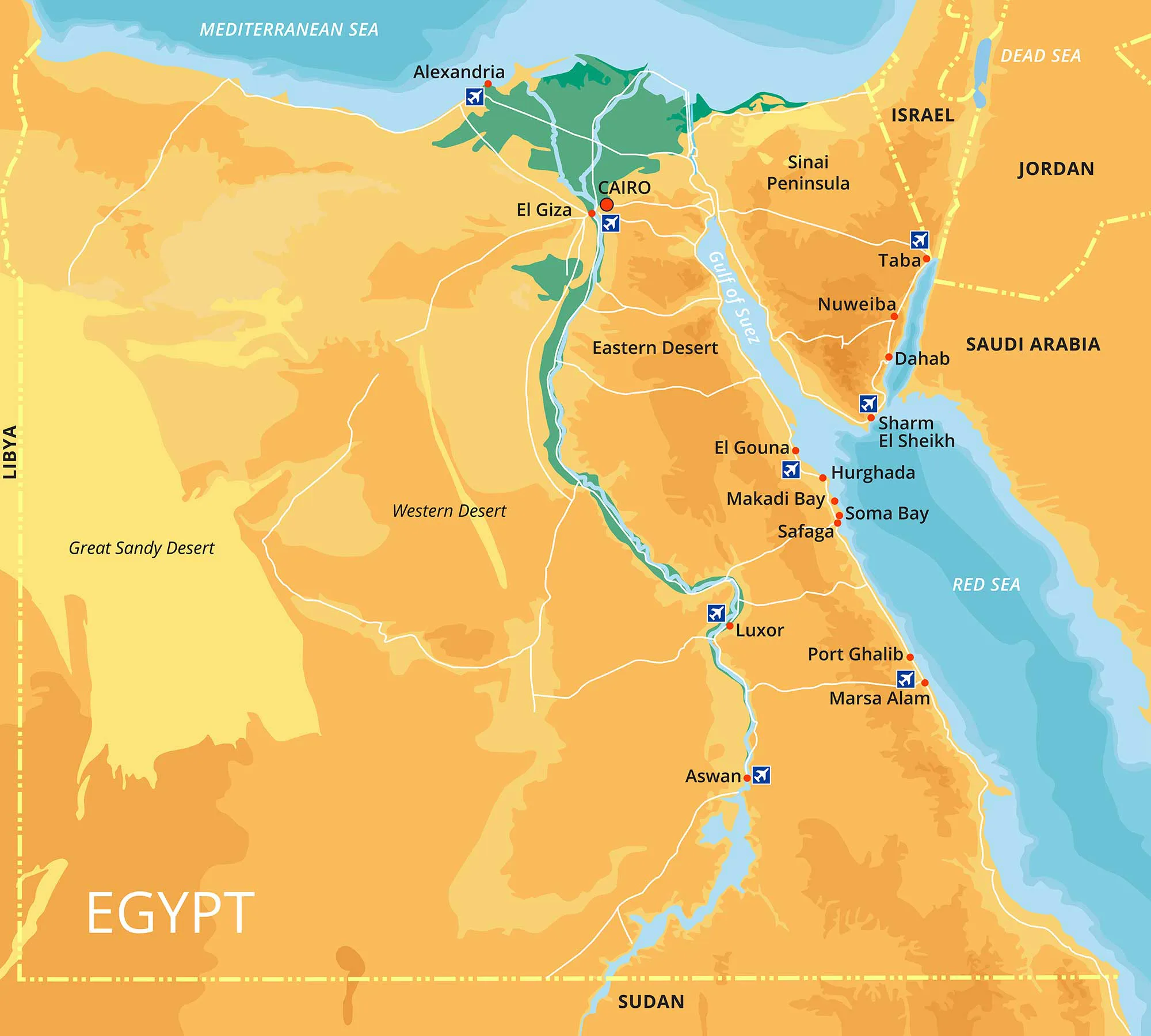
Egypt sits in the north-eastern corner of Africa, but the Sinai Peninsula carries it across the Suez Canal into south-western Asia, so the country bridges two continents. It lies roughly between latitudes 22° and 32° north and longitudes 24° and 37° east, and covers a total area of about 1,001,450 km², of which some 995,450 km² is land.
Borders and coasts
Egypt has around 2,450 km of coastline. The Mediterranean Sea forms the northern edge, from the Libyan border past Alexandria and the Nile Delta to Port Said and northern Sinai. The Red Sea runs along the east, together with the Gulfs of Suez and Aqaba either side of Sinai. On land, Egypt borders Libya to the west, Sudan to the south, and Israel and the Gaza Strip to the north-east. The land borders total about 2,600 km, the longest being with Sudan (about 1,276 km) and Libya (about 1,115 km).
Main regions
- The Nile Valley and Delta: a narrow green ribbon and a broad fan of farmland, home to the great majority of Egyptians and to Cairo, Luxor and Aswan.
- The Western Desert: about two-thirds of the country, dotted with oases such as Siwa, Bahariya, Farafra, Dakhla and Kharga.
- The Eastern Desert: rugged mountains between the Nile and the Red Sea coast, with resorts such as Hurghada and Marsa Alam on the shore.
- Sinai: a triangle of mountains and desert between the two gulfs, with St Catherine inland and Sharm El Sheikh and Dahab on the coast.
The Nile
The Nile enters Egypt from Sudan into Lake Nasser, the reservoir created by the Aswan High Dam, and flows north for the length of the country before splitting into the Rosetta and Damietta branches and reaching the Mediterranean. Almost all of Egypt’s farming and most of its towns depend on it, which is why the populated area is so small compared with the country’s total size.
Time zone
Egypt uses Eastern European Time, GMT+2. Daylight saving time was reinstated in 2023: clocks go forward one hour to GMT+3 on the last Friday of April and back on the last Thursday of October. If you are booking trains, flights or tours around those dates, double-check the local time.
Last checked October 2026. Sources: cia.gov, indexmundi.com, timeanddate.com, egypttoday.com.
Frequently asked questions
Is Egypt in Africa or Asia?
Egypt is in north-eastern Africa, but the Sinai Peninsula gives it an Asian dimension.
Which countries and seas border Egypt?
The Mediterranean to the north, the Gaza Strip and Israel to the north-east, the Red Sea to the east, Sudan to the south and Libya to the west.
What are Egypt's coordinates?
Roughly between latitudes 22° and 32° north and longitudes 24° and 37° east.